



Key takeaways
- Fall rock mapping means flying a field after harvest to map the surface rock 8″ and larger while the combine is parked and your crew still has time.
- Fly after your last fall tillage pass, or on stubble you won’t work again this fall. Working the ground after the flight changes what’s on the surface.
- TerraClear Rock Maps are delivered the next day on average, which leaves room to pick before freeze-up.
- Frost heave pushes new rock up over winter. Your fall map covers the fall pick and tells you which fields carry the most rock. If you pick again before planting, map again after snowmelt. Book that spring map before spring to lock in the best rate.
- Farmers using a TerraClear Rock Map find about 3x more rocks and pick about 3x faster.
What is fall rock mapping?
Fall rock mapping is flying a field after harvest to capture full-field aerial imagery, then using AI to find the surface rock 8″ and larger. You get a TerraClear Rock Map, usually the next day on average, with each rock at a precise GPS location and a precision plan, meaning the field-by-field action list that comes with your map.
The map covers the whole field, not a sample of it. The imagery is captured at 1.5mm ground sample distance, roughly 18 million pixels per acre, so the AI can tell a rock from a clod that a person driving by would miss. Mapping runs on drones today. TerraScout®, TerraClear’s autonomous field scout, is set to join the mix, with first deliveries targeted for fall 2027.
It works through stubble and residue. The one condition is that the rock has to be visible from above. For the basics on how rock mapping differs from a geologic map, see What Is Rock Mapping in Precision Agriculture?
Why map rocks in the fall instead of waiting for spring?
Fall has time that spring doesn’t. Harvest is done, and you know which fields just beat up the header.
Spring is short. Purdue agronomist Bob Nielsen estimates corn yield potential drops about 1% per day for plantings after roughly May 15. Every spring day spent chasing rock is a day the planter isn’t rolling.
Help is hard to find when you need it most. Danny Buls farms near Sumner, Iowa, and said it plainly: “It’s hard to find the help to be timely, to get the rocks out of the way before the planter hits the field.” That crunch is worst in April and May.
Harvest also just showed you where the problem is. The fields that ate guards and knife sections this fall are the ones to map first. That memory fades by March.
And the field is readable. Once the crop is off, rock that sat hidden in a standing crop all summer is visible from above again, even through residue.
Will a fall Rock Map still be accurate next spring?
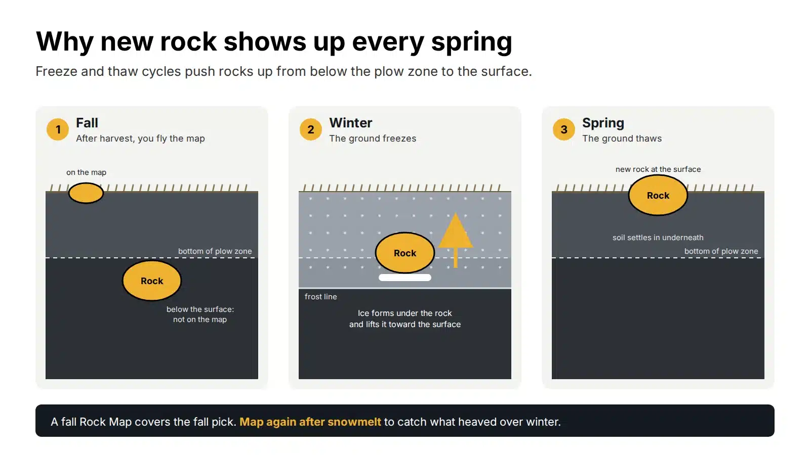
Not completely. A fall map shows the rock on the surface the day you fly. Over winter, freezing and thawing push more rock up, so some of next spring’s rock won’t be on it.
The North Dakota Department of Mineral Resources explains that “seasonal freezing and thawing cause the rocks to work upward from below the plow zone to the land surface,” which is why “each spring, a new crop of stones has to be removed from the fields.” Anyone farming glacial ground across the Upper Midwest knows the pattern.
That’s why a TerraClear Rock Map is a seasonal tool. Two rules follow from it:
- Don’t work the ground between the flight and the pick. Tillage moves rock and brings new rock up. Once you fly, leave the field alone until you’re done picking.
- Match the map to the pick. Use the fall map for the fall pick. If you plan to pick again before planting, map again after snowmelt and before any spring tillage.
So what is a fall map for? Two jobs. It gets the fall pick done faster. And it gives you a field-by-field read on where rock is heaviest, so you know which fields to put first in line next spring. If you know you’ll want a spring map too, buy it before spring. That locks in the best rate.
When should you fly a fall Rock Map?
Fly once the field looks the way it will when you pick it. For most operations that means after harvest and after your last fall tillage pass, with enough time left to pick before the ground freezes.
| Your fall plan | When to fly | Why |
|---|---|---|
| Fall tillage | After your last tillage pass | Tillage moves rock and exposes new rock. Map the field as you’ll leave it. |
| No-till or leaving stubble | Any time after harvest | The map works through stubble and residue. |
| Fall-seeded wheat or a cover crop | After harvest, before seeding | Get the rock out before the drill goes in. |
| Snow on the ground | Wait | Rock has to be visible from above. |
Freeze-up dates vary a lot by year and by location. Talk to your rep early so the flight lands with room to pick afterward. Talk to a rep about a fall map.
How do you plan a fall pick from a Rock Map?
Start with your worst fields, pull the biggest rock first, and work from the map’s route instead of hunting. Here’s the order most farmers follow:
- Rank your fields. Compare maps and start where rock is heaviest, or where the combine took damage this year.
- Filter by size. Set the size filter to the rock that breaks iron and pull that first. Come back for smaller rock if time allows.
- Set your entry and exit. Mark where you’ll come into the field and where you’ll leave so the work fits your yard and your loads.
- Follow the route. Turn on route guidance for an optimized pick route. Tap any pin to see a photo of that rock, so you can spot it as you pull up.
- Share and track. Send the map to your crew. Tracking shows which ground is covered and which rock is picked, whether you’re in the cab or somewhere else.
- Leave the ground alone until you’re done. Hold off on tillage until the mapped rock is out.
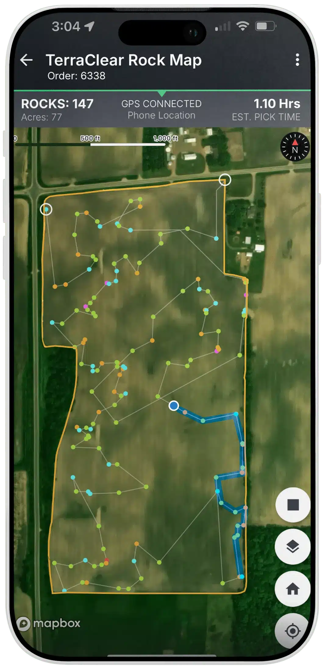
You can pick with the loader, a side-by-side, or a rock picker you already own. The precision comes from the map. If you’d rather not pick at all, TerraClear can refer you to independent rock picking operators in your area who work from your map.
Farmers working from a TerraClear Rock Map pick about 3x faster and spend up to 80% less time picking.
Should you pick rocks this fall or wait until spring?
On rocky ground, do both. Clear the worst fields this fall, then clean up what heaved over winter before planting.
| Fall pick | Spring pick | |
|---|---|---|
| Time available | After harvest, before freeze-up | Between snowmelt and planting |
| Labor | Competes with fall tillage and fieldwork | Competes with planting prep |
| Frost heave | New rock will still surface over winter | Catches the rock that heaved over winter |
| When to map | After your last fall tillage pass | After snowmelt, before spring tillage |
| Best for | Getting ahead on your worst fields | Final cleanup before the planter |
A fall pick shrinks the spring job. It won’t erase it, because frost heave keeps working all winter.
What do rocks cost you at harvest?
Rocks cost you twice: in repairs and in bushels left on the ground.
Start with repairs. Medium-scale operations can face $5,000 to $25,000 a year in equipment repairs from rock damage. Danny Buls put it simply: “As everybody knows, [the breakage] on combines can be pretty substantial.”
Then there are the bushels. Rock sets your cutting height. South Dakota State University Extension’s soybean guide notes that “rocky areas or soil mounds require the operator to raise the combine header and sacrifice low hanging pods, leaving them in the field.” That matters because header loss can be responsible for as much as 90% of total soybean harvest loss, according to Iowa State University Extension.
Rolling isn’t removal, either. A land roller presses rock down. It doesn’t take it out, and it will be back. Iowa State soil scientist Mahdi Al-Kaisi has cautioned that rolling can crush surface soil aggregates and raise the risk of crusting and erosion.
For the full math, read The Real Cost of Field Rocks.
What does Danny Buls say about his TerraClear Rock Map?
Danny Buls farms near Sumner in northeast Iowa. Before TerraClear, getting rock out ahead of the planter depended on finding help at the right time. “Since TerraClear’s been around, it’s made that whole part much easier,” he said.
At harvest, it shows up in the cab. “[When you’re] combining, you really enjoy that, not watching for them rocks,” Danny said. With that peace of mind, he can run later at night, “and everybody has a better day.”
He also values that the work gets done when promised. “If they say they’re gonna do it, they get it done.”
Frequently asked questions about fall rock mapping
Can you map rocks in the fall after harvest?
Yes. A TerraClear Rock Map works any time rock is visible from above, including through stubble and residue after harvest. Avoid flying with snow on the ground.
How fast do I get my Rock Map?
Maps are delivered the next day on average after the flight.
Do I need a new Rock Map in the spring?
If you plan to pick again before planting, yes. Frost heave brings new rock to the surface over winter, so a spring map made after snowmelt catches rock the fall map couldn’t. Buy it before spring to lock in the best rate.
Can I till after the flight?
Not until you finish picking the mapped rock. Tillage moves rock and brings new rock up, so the map no longer matches the field.
What size rock does a Rock Map find?
TerraClear Rock Maps detect rock 8″ and larger, each with a GPS-pinpointed location and a photo.
Does TerraClear pick the rocks?
No. TerraClear makes the map. You pick with your own equipment and crew, or TerraClear can refer you to an independent rock picking operator.
Get your fall map on the calendar
The window between harvest and freeze-up is short. Talk to a rep about mapping your rockiest fields this fall. Ask about booking your spring map now to lock in the best rate, and find out who covers your area.
Talk to a rep about a fall map
Sources
- Glacial Erratics, North Dakota Department of Mineral Resources
- The Planting Date Conundrum for Corn, R.L. Nielsen, Purdue University
- Verifying Combine Adjustments During Crop Harvest, Kapil Arora, Iowa State University Extension, Sept. 26, 2019
- Soybean production guide, South Dakota State University Extension
- Rolling Stones: If You Have Rocks (and Root Balls), Should You Roll?, Farm Progress

Don Scribner is Director of Product at TerraClear, where he leads development of TerraClear Rock Maps, Weed Maps and development of TerraScout. He has spent 19 years in agricultural manufacturing and technology, building products around what farmers actually need in the field. He is based in Grangeville, Idaho.