


Precision Ag Mapping, From Rock Management to Farm Weed Management
YesPress profile, June 2026. A new third-party profile traces TerraClear from a 2017 start in Issaquah, Washington to about 1,000 farm customers and $53 million raised. Here is the part that matters if you farm.
Estimated reading time: 4 minutes
What the profile covers
YesPress looked at how TerraClear built a precision ag business around one idea: you cannot manage what you have not measured. The company flies the whole field, runs the imagery through computer vision, and hands back a prescription the operator can act on the next morning. Rocks and weeds are the two problems it maps today.
The numbers behind the company
- Founded December 2017. Headquarters in Issaquah, Washington, with a second location in Grangeville, Idaho.
- About 1,000 customers and roughly 52 employees.
- $53 million raised since 2017.
- Devin Lammers has been CEO since August 2024. Founder Brent Frei is chairman. Trevor Thompson is president.
Whole-field mapping, not sampled
Most field scouting is a sample. Somebody walks a few passes, or glances out the windshield, and the rest of the section gets a guess. TerraClear maps every acre at 1.5 mm ground sample distance, which works out to roughly 18 million pixels per acre. That is the first of two real differences. The second is speed: maps come back next day on average, not next month.
Rock Map: find more, pick faster
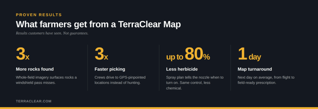
A TerraClear Rock Map reliably detects rocks 8″ and larger and marks them at centimeter-level precision. Customers have found roughly three times more rocks than they were finding on their own, and picked about three times faster, because the crew drives to a GPS-pinpointed location instead of hunting. The picking stays yours. Run your own crew and iron, or ask us to refer you to an independent picking operator working your area.
Weed Map: same control, less chemical
A TerraClear Weed Map does the same job for weed pressure. You get a whole-field map delivered as a precision spray plan that tells a section-control or nozzle-control sprayer when to turn on. Farmers running it have used up to 80% less herbicide. Same control, less product across the gate.
How a prescription reaches your equipment
Rock Map output
A pick route and a full-field tracking view in the TerraClear Mobile app, so you know which acres are cleared and which are not.
Weed Map output
A spray plan your existing sprayer reads. John Deere, Ag Leader, and Case IH are all supported. No new brand of iron required.
TerraScout and what comes next
TerraScout™ launched in February 2026. It is an autonomous ground scout that covers more than 1,000 acres a day, runs at 15 mph, and goes about six hours between refuels. Mapping is flown by drone today. Over the next year it moves to a mix of drone and TerraScout, which extends the window when conditions ground a drone. If you’re interested in using TerraScout on your farm, you can reserve your unit here.
What the leadership team said
“TerraScout will scout entire fields in almost any condition and convert that intelligence to precise action for existing crews and equipment.”
Devin Lammers, CEO, TerraClear
What it means for your operation
If you farm 1,000 acres or more and you are still guessing where the rocks and the weeds are, the map is the cheapest part of the fix. Pick the field that costs you the most time this year and map that one first.
Explore TerraClear mapping
- TerraClear Rock Map
- TerraClear Weed Map and weed management
- All rock and weed management solutions
- The AI technology behind the maps
- TerraScout launch announcement
- Support and FAQs
- Service Operators Program
- About TerraClear
Read the coverage
- YesPress: TerraClear Inc profile (source)
- GeekWire: TerraClear launches autonomous farm robot to capture images for tackling rocks, weeds and more
- AgFunderNews: From rocks to row crops, TerraClear broadens its capabilities with launch of fully autonomous robot
Get a map on your field
Tell us the field and the acres and we will get you a quote. Talk with our team.
Results shown are outcomes customers have measured, not guarantees. Mapping marks GPS-pinpointed locations at centimeter-level precision. TerraClear does not claim to find every rock or every weed.